- Australia ▾
- Topographic
▾
- Australia AUSTopo 250k (2024)
- Australia 50k Geoscience maps
- Australia 100k Geoscience maps
- Australia 250k Geoscience maps
- Australia 1.1m Geoscience maps
- New Zealand 50k maps
- New Zealand 250k maps
- New South Wales 25k maps
- New South Wales 50k maps
- New South Wales 100k maps
- Queensland 10k maps
- Queensland 25k maps
- Queensland 50k maps
- Queensland 100k maps
- Compasses
- Software
- GPS Systems
- Orienteering
- International ▾
- Wall Maps
▾
- World
- Australia & New Zealand
- Countries, Continents & Regions
- Historical
- Vintage National Geographic
- Australian Capital Territory
- New South Wales
- Northern Territory
- Queensland
- South Australia
- Tasmania
- Victoria
- Western Australia
- Celestial
- Children's
- Mining & Resources
- Wine Maps
- Healthcare
- Postcode Maps
- Electoral Maps
- Nautical ▾
- Flags
▾
- Australian Flag Sets & Banners
- Flag Bunting
- Handwavers
- Australian National Flags
- Aboriginal Flags
- Torres Strait Islander Flags
- International Flags
- Flagpoles & Accessories
- Australian Capital Territory Flags
- New South Wales Flags
- Northern Territory Flags
- Queensland Flags
- South Australia Flags
- Tasmania Flags
- Victoria Flags
- Western Australia Flags
- Gifts ▾
- Globes ▾
Dear valued customer. Please note that our checkout is not supported by old browsers. Please use a recent browser to access all checkout capabilities


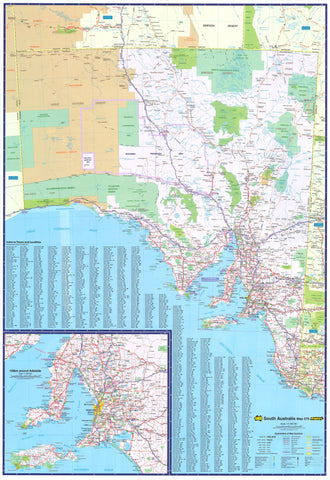
Adelaide & Region Hema 1000 x 1430mm Supermap Paper Wall Map
$129.95
or make 4 interest-free payments of
$32.49 AUD
fortnightly with
![]() More info
More info
This Greater Adelaide Map by Hema covers the area from Gawler Belt in the north down to Willunga in the south and Charleston in the east.
It features all primary and secondary roads and shows the met roads, national and state route numbers, and present and future freeways.
This easy-to-read map makes a great wall map for business planning as it shows all the postcodes and includes a suburb index.
This map is printed on high-quality FSC 170 gsm matt-coated paper using archival-grade pigment ink, making it perfect for framing under glass.
Scale: 1:56,000
Size: 1430 mm (h) x 1000 mm (w)