- Australia ▾
- Topographic
▾
- Australia AUSTopo 250k (2024)
- Australia 50k Geoscience maps
- Australia 100k Geoscience maps
- Australia 250k Geoscience maps
- Australia 1.1m Geoscience maps
- New Zealand 50k maps
- New Zealand 250k maps
- New South Wales 25k maps
- New South Wales 50k maps
- New South Wales 100k maps
- Queensland 10k maps
- Queensland 25k maps
- Queensland 50k maps
- Queensland 100k maps
- Compasses
- Software
- GPS Systems
- Orienteering
- International ▾
- Wall Maps
▾
- World
- Australia & New Zealand
- Countries, Continents & Regions
- Historical
- Vintage National Geographic
- Australian Capital Territory
- New South Wales
- Northern Territory
- Queensland
- South Australia
- Tasmania
- Victoria
- Western Australia
- Celestial
- Children's
- Mining & Resources
- Wine Maps
- Healthcare
- Postcode Maps
- Electoral Maps
- Nautical ▾
- Flags
▾
- Australian Flag Sets & Banners
- Flag Bunting
- Handwavers
- Australian National Flags
- Aboriginal Flags
- Torres Strait Islander Flags
- International Flags
- Flagpoles & Accessories
- Australian Capital Territory Flags
- New South Wales Flags
- Northern Territory Flags
- Queensland Flags
- South Australia Flags
- Tasmania Flags
- Victoria Flags
- Western Australia Flags
- Gifts ▾
- Globes ▾
Dear valued customer. Please note that our checkout is not supported by old browsers. Please use a recent browser to access all checkout capabilities
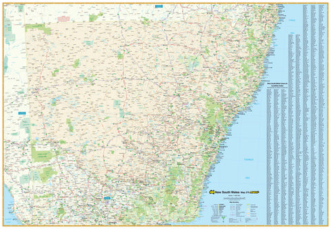
New South Wales 270 UBD Map 1000 x 690mm Canvas Wall Map
$199.00
or make 4 interest-free payments of
$49.75 AUD
fortnightly with
![]() More info
More info
This striking map of New South Wales by UBD also includes the Australian Capital Territory. The map clearly shows dual carriageways, national highways, and other roads, distances between towns, route numbers, towns with an indication of each town's size and a comprehensive listing of towns, localities & homesteads. Also included are visitor information centres, national, state and marine parks. This easy-to-read map will help you find your way around New South Wales and is perfect for business or leisure.
This map is printed on heavy-duty 395 gsm HP Professional Matte Canvas using pigment-based inks - making the map highly durable and fade resistant. The exceptional clarity of printing makes this map a stunning addition to any room, and its high quality means that it will provide years of enjoyment.
The easiest way to hang this map is by having wooden battens attached top and bottom with a hanging cord running along the top batten. This way, all you need to do is hang it from a hook. You can select this option from the dropdown above, where it says Finish.
Scale: 1:1,600,000
Size: 1000 mm (w) x 690 mm (h)


